


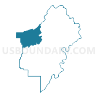
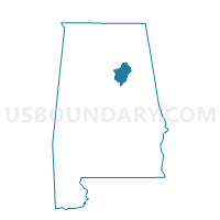
Springville Me C Voting District, St. Clair County, Alabama
About
Outline

Summary
| Unique Area Identifier | 522866 |
| Name | Springville Me C Voting District |
| County | St. Clair County |
| State | Alabama |
| Area (square miles) | 73.83 |
| Land Area (square miles) | 73.33 |
| Water Area (square miles) | 0.50 |
| % of Land Area | 99.32 |
| % of Water Area | 0.68 |
| Latitude of the Internal Point | 33.76958210 |
| Longtitude of the Internal Point | -86.46415940 |
Maps

Graphs
Select a template below for downloading or customizing gragh for Springville Me C Voting District, St. Clair County, Alabama


Neighbors
Neighoring Voting District (by Name) Neighboring Voting District on the Map
- Ash Civic Center/Friendship Fire Dept. Voting District, St. Clair County, AL
- Branchville Church/ Odenville Civic Center Voting District, St. Clair County, AL
- Chandler Mt.Comm/Gallant Fire Dept./Slate Union Voting District, St. Clair County, AL
- Clay Community Center, Jefferson County, AL
- Holly Springs, Blount County, AL
- Margaret Town Hall Voting District, St. Clair County, AL
- Pine Mountain, Blount County, AL
- Pinedale Fire Dept. Voting District, St. Clair County, AL
- Straight Mountain, Blount County, AL
- Trussville First Baptist Church, Jefferson County, AL
- Whites Chapel Voting District, St. Clair County, AL
Top 10 Neighboring County Subdivision (by Population) Neighboring County Subdivision on the Map
- Moody CCD, St. Clair County, AL (25,023)
- Springville CCD, St. Clair County, AL (20,727)
- Trussville CCD, Jefferson County, AL (19,104)
- Oneonta CCD, Blount County, AL (14,908)
- Clay CCD, Jefferson County, AL (13,695)
- Locust Fork CCD, Blount County, AL (8,731)
- Ashville CCD, St. Clair County, AL (8,449)
Top 10 Neighboring Place (by Population) Neighboring Place on the Map
- Trussville city, AL (19,933)
- Clay city, AL (9,708)
- Springville city, AL (4,080)
- Argo town, AL (4,071)
- Odenville town, AL (3,585)
Top 10 Neighboring Unified School District (by Population) Neighboring Unified School District on the Map
- Jefferson County School District, AL (230,679)
- St. Clair County School District, AL (53,540)
- Blount County School District, AL (50,755)
Top 10 Neighboring State Legislative District Lower Chamber (by Population) Neighboring State Legislative District Lower Chamber on the Map
- State House District 50, AL (55,378)
- State House District 34, AL (50,560)
- State House District 44, AL (48,707)
- State House District 51, AL (48,552)
- State House District 30, AL (44,979)
Top 10 Neighboring State Legislative District Upper Chamber (by Population) Neighboring State Legislative District Upper Chamber on the Map
- State Senate District 15, AL (160,461)
- State Senate District 17, AL (157,178)
- State Senate District 12, AL (142,431)
Top 10 Neighboring 111th Congressional District (by Population) Neighboring 111th Congressional District on the Map
Top 10 Neighboring Census Tract (by Population) Neighboring Census Tract on the Map
- Census Tract 405.01, St. Clair County, AL (11,002)
- Census Tract 405.02, St. Clair County, AL (9,725)
- Census Tract 401.03, St. Clair County, AL (8,758)
- Census Tract 507, Blount County, AL (8,731)
- Census Tract 111.11, Jefferson County, AL (8,018)
- Census Tract 501.01, Blount County, AL (7,858)
- Census Tract 111.10, Jefferson County, AL (5,677)
- Census Tract 111.09, Jefferson County, AL (4,123)
- Census Tract 404.02, St. Clair County, AL (3,718)
Top 10 Neighboring 5-Digit ZIP Code Tabulation Area (by Population) Neighboring 5-Digit ZIP Code Tabulation Area on the Map
- 35173, AL (25,176)
- 35126, AL (21,725)
- 35121, AL (15,570)
- 35120, AL (13,842)
- 35146, AL (10,948)
- 35133, AL (3,907)
- 35112, AL (801)